Monitoring river temperatures is a key tool for biologists to better understand climate change impacts on fish habitat
Initial observations in water temperatures across coastal rivers being monitored have seen a slight increase since the study began in 2014.
Understanding the river landscapes that support aquatic species is vital for management and conservation strategies and gauging river temperatures to provide fisheries biologists more awareness of climatic tolerances of fish species like the Pacific salmon.
The Washington Department of Fish and Wildlife (WDFW) is collaborating with coastal tribes and salmon recovery practitioners, as well as other local, state, and federal organizations on an extensive study of stream temperatures in watersheds of the Washington coast.
The scope of this ongoing project, that began in 2014, is to develop maps of river temperatures known as “thermalscapes” with estimates of uncertainty, across a broad scale. Estimates of uncertainty refer to confidence intervals in the model and help understand how precise the estimates are. The smaller the confidence intervals, the more certain the estimate is close to the actual value.
The goal is to understand patterns of river temperatures across multiple watersheds and important environmental factors influencing these patterns. In addition, the project leverages climate change models to predict stream temperatures late this century (2080s) to help researchers strategize about how to conserve, protect, and restore important fish habitat in future decades.
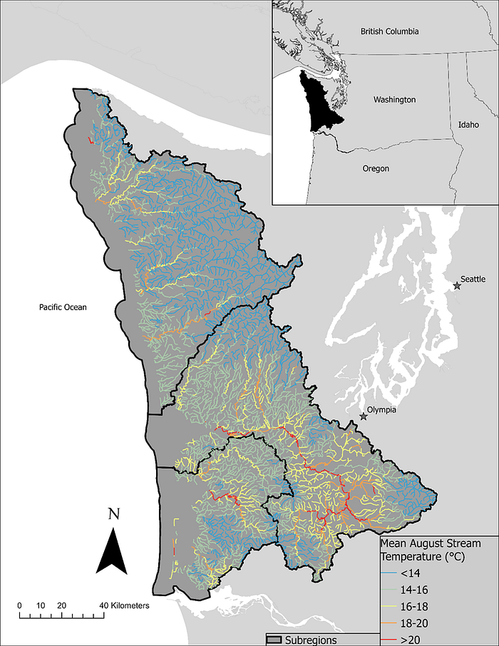
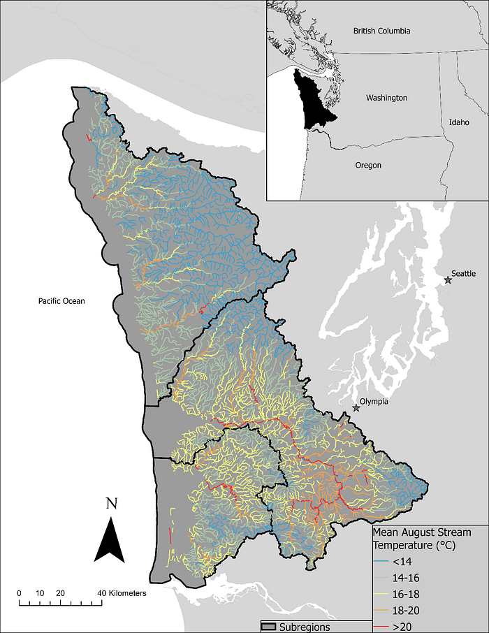
The resulting Washington Coast Thermalscape Model, published in August 2023 by WDFW fish biologist John Winkowski, includes a spatial stream network model of mean August temperatures and uses millions of observations from 564 monitoring locations across coastal Washington.
“August is when temperatures tend to be warmest and most stressful for fish, so it made sense to see just how hot summer temperatures currently are and how hot they are likely to get,” said Marisa Litz, WDFW fisheries scientist.
Initial observations in water temperatures across coastal rivers being monitored during August have seen a slight increase since the study began in 2014. Water temperatures are expected to gradually increase even more later in this century.
“I think that it is important to note that the increases in temperature are not happening at the same rate across all of the coastal watersheds,” Litz said. “Some areas will warm faster and higher than others.”

This work was selected for funding by the Washington Legislature as part of WDFW’s Climate Readiness Package.
The Washington Coast Thermalscape model is already being used by:
· The Chehalis Basin Strategy in the Aquatic Species Restoration Plan, the largest investment in habitat restoration in the history of Washington.
· The Coast Salmon Partnership’s Climate Adaptation Framework to help with climate resiliency and watershed planning.
· Researchers to predict range expansion of smallmouth bass, a predator of juvenile salmon, in the Chehalis River Integrating Spatial Stream Network Models and Environmental DNA to Estimate Current and Future Distributions of non-native smallmouth bass (Micropterus dolomieu). Research article in press Transactions of the American Fisheries Society.
The Washington Coast Thermalscape Model uses the same approach as the NorWeST Stream Temperature Model in rivers across the western United States but includes many more data points in the region than were available during NorWeST development.
The Washington Coast Thermalscape Model is for the Washington Coast Salmon Recovery Region — Willapa Bay to the outer Olympic Peninsula — and is a collaboration between WDFW and the Chehalis Tribe, Quinault Indian Nation, Hoh Tribe, Quileute Tribe, Washington Department of Ecology, Washington Department of Natural Resources, National Park Service, U.S. Forest Service, and U.S. Geological Survey. The study was funded by the Coast Salmon Partnership.